
Travel & tourism is an ever changing environment, and knowing how to engage visitors can be a huge boost.
In an increasingly connected world, it’s becoming easier to leverage the power of devices visitors have at their fingertips. Offering additional content at your site can entice younger audiences while keeping them entertained.
Whether you’re exploring ancient ruins, learning about local wildlife, or simply seeking an elevated outdoor adventure, AR trail-based apps are quickly becoming the next frontier in both outdoor recreation and technology.
One such method developed by Harmony Studios, is our GeoLocation and Marker Experience (GLME) Framework, which is a proprietary solution designed to harness the synergy between synergy between geographic information and interactive markers, offering a powerful toolset for creating immersive, location-based digital experiences.
What Are AR Trail-Based Apps?
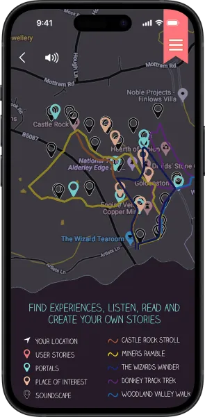
At their core, AR trail-based apps blend the physical world with interactive digital content, making use of advanced geolocation and augmented reality technologies. As users move along a real-world trail, the app uses GPS to track their location, displaying AR objects or information at specific points of interest (POIs) on the trail. This technology can bring historical landmarks to life, offer educational facts, or guide hikers through unfamiliar terrain with visual markers and prompts.
What is the GeoLocation and Marker Experience Framework?
The GeoLocation and Marker Experience Framework is a comprehensive solution that integrates geolocation technology with interactive markers to provide interactive digital experiences. It combines the precision of geographic positioning with the versatility of visual markers to deliver applications that are both location-sensitive and richly interactive.


How It Works
At the core of our framework is robust geolocation technology. By leveraging GPS, Wi-Fi, and cellular network data, the framework can pinpoint a user’s location with high accuracy. This geolocation data enables applications to deliver content or trigger interactions based on the user’s physical position.
Interactive markers are visual or digital cues that users can interact with. These markers can be images, QR codes, SLAM, or augmented reality (AR) objects that serve as points of interest. When combined with geolocation data, these markers provide a dynamic layer of interaction. For instance, a museum exhibit might use AR markers to display additional information or multimedia content when a visitor is in the vicinity.
The framework integrates these two components seamlessly. It allows for the creation of geofences—virtual boundaries based on geographic coordinates—within which specific markers become active. For example, a mobile app might show a special offer when a user enters a defined geofenced area and scans a QR code.
The content and locations are all controlled by our purpose-built GLME CMS (Content Management System). Whether you need to add a new location, update some copy or set up a new minigame, all of this can be controlled via the system. Better yet, the system will then supply you with live analytics, helping you to measure your engagement at each location.
Key Features
Advanced Analytics: Leveraging the purpose-built API you can see how your users are interacting with your application and which locations are achieving the highest interactions.
Real-Time Location Tracking: The framework supports real-time tracking, enabling applications to provide up-to-the-minute updates and interactions based on the user’s location.
Versatile Marker Types: Supports various types of markers, including AR elements, QR codes, and image recognition markers, offering flexibility in how content is presented.

Customisable Interactions: We can design custom interactions and responses triggered by both location and marker data. This can include displaying information, initiating actions, or triggering animations.
Cross-Platform Support: The framework is designed to work across multiple platforms, including mobile apps and web applications, ensuring a consistent experience regardless of the device.
CMS Control: The framework allows for management via the GLME Portal allowing you to stay up to date.
Why AR Trail-Based Apps Are Gaining Popularity
1. Immersive Learning Opportunities
AR trail apps are not just for entertainment—they offer rich educational experiences. Historical re-enactments, virtual nature tours, and interactive learning can turn a simple hike into a lesson in history, biology, or geology. AR’s capacity to visualise complex information and make it interactive appeals to users of all ages, enhancing the learning process while being fun and engaging.
2. Engaging Younger Generations
In a time when outdoor activity competes with screens for attention, AR trail-based apps are an effective way to bridge the gap. These apps combine the best of both worlds—adventure and technology. Gamified AR experiences keep younger hikers entertained while exploring nature, making family outings more dynamic and enjoyable.
3. Navigational Assistance
Some of the most practical applications of AR on trails revolve around navigation. Instead of using a 2D map, AR apps can provide visual markers that guide hikers in real time. With AR waypoints or a virtual guide overlaying your route, staying on track becomes easier, particularly on unfamiliar or unmarked trails.
Benefits
Improved Analytics: Enables tracking of user interactions and behaviours based on location and/or marker usage, providing valuable insights for optimisation and improvement.
Enhanced User Engagement: By combining location and interactive markers, the framework creates engaging and personalised experiences that capture user interest and increase interaction.
Context-Aware Content Delivery: Provides relevant content based on the user’s location and interactions, making digital experiences more meaningful and contextually appropriate.
Flexibility and Customisation: Offers extensive customisation options to tailor interactions and content to specific needs and scenarios. Want a new feature? The Harmony Team are on hand to help you achieve this.
Conclusion
AR-powered trail-based apps are transforming the way we explore the outdoors. By combining geolocation, image recognition, and SLAM technologies, these apps offer immersive, educational, and highly engaging experiences. As AR continues to evolve, outdoor adventurers can look forward to an exciting future where nature and technology come together in ways we’ve never imagined before.
Embrace the future of digital interaction with the GLME Framework from Harmony Studios, and transform how your users experience the world around them. So, the next time you lace up your hiking boots, don’t forget to bring your smartphone—your next adventure may be more magical than you think!
-
Date
Oct 1, 2024
-
Sectors
Travel & Tourism
Training & Education
Consumer
Entertainment
-
Services
Augmented Reality Development
Web systems
Gamification
GeoLocation and Marker Experience (GLME)
Max 500 characters (0/500)